<Schmittenhohe - 4 LAKE HIKING>
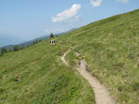
In the next morning, I rode up on the lift to Schmittenhohe and from there walked along the trail No.50 dubbed as “4 LAKE HIKING”, which was one of the recommended routes for a hiker with some experience by the city's simple hiking guide. Starting the Schmittenhohe top with the height of around 2000 meter, I could easily trail the path per guideposts. It was a really nice walking, breathing in cool mountain air and having a great view of Austrian alpine scenery on a sunny summer holiday.


<Kitzsteinhorn - Gipfelwelt 3000>
In the afternoon after 4 LAKE HIKING, I descended to Zell and headed for Kaplan on a local bus to see Kitzsteinhorn glacier and have a panorama view from Gipfelwelt 3000 lookout.


While planing in Japan, I was thinking about taking part in a guided tour to the Kitzsteinhorn summit (3,203m altitude) led by a state qualified alpinist. But this requires the ascent of 200 meter altitude being fastened to a rope with other climbers and I was not so sure of it, so abandoned this idea. Instead, I just changed to a different lift up three times, which took me to 3,000 meter altitude so easily in less than 50 minutes. At the top, I walked down to an ice field, excited with the cool touch of summer snow under the strong summer sunshine just as kids playing with sleighs. Back to the Gipefelwelt 3000 lookout, I enjoyed the magnificent view of mountains in the Hohe Tauern National Park.
<Pinzgauer Spaziergang>
This hiking trail also starts from the top of Schmittenhohe lift and stretches along the mountain ridge of Kitzbühel Alps to Saalbach. It requires 6 hours of pure walk, all-day hike so that good physical condition and strength is a must. But the guide book stresses this hike as one of the most beautiful high trails in the eastern Alps with magnificent views of the Kitzbühel Alps and Hohe Tauern range.
I met a senior hiker from London at the pension. He also came alone to challenge this route to celebrate his 61 years birthday. But on the next day while chatting, he persuaded me not to take this route as he had been forced to retreat somewhere on the way due to the long walk under the heated sun, saying that it would be very tough for a senior lonely hiker like him and me. Anywhere I decided to go on this trail as far as I could.


Around two hours walking from Schmittenhohe, I encountered a senior German hiker returning from the opposite direction and we talked for about one hour, considerably long time for a hiking rest, siting on rocks under the shadow of trees. He started earlier with a tour group, but decided to return to Schmittenhohe. He was of almost same age as me, we felt some familiar feeling each other. He had experiences to visit Japan several times as a chemical company's engineer before retirement, saying he knew some people of the Japanese chemical company which I'm currently working for. Walking alone on a desolate trail makes sometimes a lonely hiker talkative.


30 minutes after waving good-by with him, I reached the mountain hut dubbed "Hochsonnberg Alm" situated at 1841m altitude. This hut welcomes hikers with a menu of specialties and a magnificent view of snow-capped Kitzsteinhorn mountains. Instead of a beer, I ordered a juice, a kind of lemonade, which looked like just water, but tasted subtly sweet and very refreshing. The master said they made this with mountain cool water and asked me how I liked it. It was certainly the most refreshing juice I ever had drunk.


A gently sloping uphill from the hut took me to the saddle point called Rohrertori, where there were no human beings but cattle and horses grazing peacefully and some of them took a suspicious glance at me when I passed by. But this was just the entrance of a maze that made me losing my way. There was certainly a guidepost that might have indicated the right way, but it was written in German with an unfamiliar place name. I tried to make a detour not to interrupt those cattle and horses grazing. I continued to walk on for more than one hour until I found it was not the right way to Saalbach. On this Alm, I learned that broader trails are for those cows and hikers should choose rather narrow roads. When back to Rohrertori, I lost two hours and decided to return to where I came from just as my two fellow colleagues.
<Kaiser Franz Joseph Hohe>
On the 4th day in Zell Am See, I joined in the bus tour to Kaiser Franz Joseph Hohe conducted by National Park Rangers. I had been wondering whether I should rent a car to go there, but Ms. Mondre of the pension looked for a nice bus tour and made a booking for me. It was very economical because of its discounted fee of 22euro thanks to a Zell Am See Card and also eco-friendly. I got in the bus at 9:00 at Zell and a park ranger started to explain us in English about the today's tour and the nature of the Hohe Tauern National Park. The bus drove on the Grossglockner High Alpine Road, one of Europe’s greatest alpine road,which connects Bruck and Kaiser-Franz-Joseph-Höhe (2369m), 48 kilometers long with its 36 hairpin curves and a splendid view of glacier mountains.


Our first bus stop was the Alpine Nature Show Museum at an altitude of 2260 meters above sea level, which highlighted its local mineral and flora exhibition. From the nearby lookout, I enjoyed the scenic view of glaciated peaks including 3564m Grosses Wiesbachhorn.


At 12 o'clock the bus arrived at Kaiser Franz Joseph Hohe Visitor Center (2369m). I followed our park ranger to the crystalline Wilhelm-Swarovski observatory, listening his explanation about the area's fauna, rapidly retreating
Pasterze Glacier and climbing route to the top of Mt. Grossglockner; "The Grossglockner is the Austria's highest mountain, 3, 798 meters high above sea level with the longest glacier in the eastern Alps, the Pasterzeand. You can see lovely marmots socializing each other near the center and if you are lucky enough, the mighty ibex might loom up in the fog." But looking at the retreating glacier made me realize how the global warming has presented itself as a real threat to human beings.


We had two hours to explore the site before 14 pm, the departure time of bus. I took a lunch at a restaurant with a great view of Grossglockner behind the back of ibex statue, ordering "Leberkase", fried egg with potato salad for 9.8 euro and 0.3L draft beer for 3.2 euro. In return, our bus descended the same zigzag road back to Zell and stopped in a half hour at Fuscher Lake (2262m) for a short coffee break. The lake was calm with the sound of melting snow flowing into it and reflecting the surrounded mountains images. On the road side, people gathered to see a marmot coiling around the neck of his master.


The Grossglockner High Alpine Road had been constructed between 1930 and 1935, during the Great Depression, around 80 years later after the visit by the Emperor Franz Joseph. Although the construction was motivated by the people's anticipation toward the opening of motorized tourism, they are also eager to protect the area's natural environment. The local people advised me not to use rent-a-car, but recommended me to take part in a bus trip. I heard the touring bus was launched in 2012 for sustainability reasons as well as offering an easy access to the region's unique natural beauty.
(to be continued; next "Lienz")
The other blogs related to "A senior hiker on Austrian Alps"
1. "Mt. Schafberg from Salzburg" posted on Aug. 4, 2015