Saturday, January 29, 2022

Shiretoko to north to Rebun, Hokkaido, July 2021

  On July 25, I set off the Narita airport to travel the northern part of Hokkaido together with my old friend. This was the first time that I used the LCC flight. Although this time of the year was usually the high season for tourists, there were many vacant seats in the Peach flight due to the pandemic and the government strict restrictions on travel. I could occupy all three seats in a row. This direct flight to Memanbetsu airport in Abashiri county took about 2 hours and cost me less than 10K yen, one thirds of those of major flights connecting to big cities in Hokkaido like Sapporo, Asahikawa and Hakodate, so really comfortable, cheap, and safe in terms of the panedemic. After landing, we immediately headed for a car rental service company and rented a car for 43,000 yen for 8 days. This was the start of my nostalgic tour to look over those mountains which more than a half century ago I climbed up with my university friends of the hiking club carrying tents. Back then we had crossed the Shiretoko peninsula over Mt. Raus and went up to the peak of Mt. Risiri on Risiri Island from the almost sea-level zone. Now this time, I was planning to see those mountais from the distance with nostalgic memories in my mind.


Mt. Raus


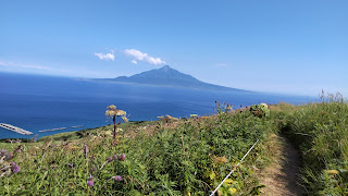
Mt. Risiri above the sea 


My planned route to explore the northern part of Hokkaido is shown in the following map.


On the first night we stayed at the Youth Hostell that stood by the Lake Saroma, less than 50 km away from the airport.

Lake Saroma Wakka Nature Center

 The next morning, on the way to Shiretoko, we dropped by the Lake Saroma Wakka Nature Center, which is the base for exploring the Wakka primeval flower garden. There are more than 300 species of the seaside plants including Hamanasu, rugosa rose on the long 20 km sand bar between the Sea of Okhotsk and the Lake Saroma. We could enjoy the quite moment strolling around the wild flower park with almost no visitors seen except us. A woman in the center said, "Unusully, they have had no rain for a month. Although the name of Wakka means "fresh water" in Ainu, most of flowers looked gone away.  


Shiretoko national park

From the Wakka, we drove east on the national highway 244 to reach at noon to Raus, a fishing port, of which we had a panormic view from the nearby observatory. After taking a lunch with full of sea food products at a small restarunt, we further drove down toward the edge of the peninsular along the seashore overlooking Kunashiri Island, our legitimate territory siezed by Russia after the world war 2.


Nearly one hour drive took us to the very small hot springs called Seseki on a reef, which submerges at high tide while gets too hot, 71 degree Celsuis, to take a bath in at low tide. From here we returned back on the same road to Raus.


From Raus we took the National Route 334 dubbed as Shiretoko crossing road and crossed the Peninsula heading for Utoro. People can drive through this route only during the period between May and November due to the heavy snow accumulation in the other seasons. We continued to go up on the road with a succession of shap turns and reached the mountain pass called Rausu pass. It was unusually clear sunny day and we were so lucky to have a splendid view of Mt. Rausu (羅臼岳). More than a half century ago I climbed up to that peak from Rausu town carrying tents with my university friends. I remembered that we had walked cross the yellow river with sulfur, being cautious about meeting abruptly wild bears on the way,  and taking a bath in the wild hotsprings at mid-night near the campsite. 


From the pass we drove down to Utoro where we were going to stay for two nights to explore Shiretoko national park. Our lodging was called as “Shucho-no-ie”, meaning a chief of indigenous Ainu”, which was conveniently located to the ferry port.

 Shiretoko Peninsula Cruising

The name of "Shiretoko" comes from the Ainu word that stands for "End of the Earth".  The Shiretoko peninsula is 70 km long and 25 km wide at its base with the highest peak of Mt. Rausu, a stratovolcano, standing 1,661 m high above the sea level on the middle of the peninsula. Along the coastline on the western side, a row of cliffs shaply plunge into the sea, which had been formed by ice drifts eroding lava flows since the volcanic eruption of Mt. Rausu that first occurred more than 100K years ago. In 2005, Shiretoko was designated a World Natural Heritage site for its unique "Biodiversity". The area is home to varieties of land and marine animals and plant species. Salmon, marine mammals such as Steller's sea lions and cetaceans, sea birds such as spectacled guillemot, Steller's sea eagle, white-tailed sea eagle, and migratory birds. The diversity of these creatures as well as its unique fauna created by the interaction between ocean, river, and forest ecosystems have been attracting nature lovers from around the world.

In my planning, I decided to explore the area extensively in three different approaches, by walking in the forests, driving through high-ways to grasp the entire landscape, and using a ferry boat to have a view of the coastline from the sea side. So we got on board the small cruise ship to go to as far as Shiretoko Cape, the longest course among the three cruise options. We sat at the top front deck of the boat and felt as if we were rushing into the Sea of Okhotsk with an abundant of marine blessings like adventurers. We were also looking to see the Shiretoko brown bears strolling along the unmanned beach searching for food.      


Shiretoko Goko Lakes (知床五湖)

After taking lunch at a tavern-like restraunt near to the ferry boat, we headed to  Shiretoko Goko Lakes, five small and mysterious lakes sleeping in the forest at the foot of Mt.Rausu, hoping to better understand the fauna created by the interactions between volcanic activities and the Sea of Okhotsk as well as enjoying the promenade around five lakes. This is the protected area to preserve the biological diversity for future generations, administered by the Japanese government . At the Shiretoko Nature Center we were told that during the period from May to July when brown bears become most active in a year, hikers are not allowed to step in the area without a guide. So we had no other choice to take part in this guided ecological tour. The guide who led us, 6 people in total, explained us about how the 5 lakes had been formed and what kind of animals and plants we could observe on the way. He sometimes shouted loudly toward the deep forest in order to let bears to know that some human beings might be approching to them.  According to him, once at least one brown bear is witnessed, all the hikers within the area are required to immediately stop walking and return to the entrance gate quickly. He emphasized that this was not the tour to show visitos wild bears, but to guide them safely not to meet bears. His explanation reminded me of one mountain ranger in Rocky Mountains, Canada around 10 years ago. She told me that they were really concerned about bears and tring so hard to protect them from human beings. She emphasised that she was trying to protect bears, not hikers. The lakes were extremely quite with the mysterious atmosphere. But I was a little bit of disappointed with no bears in sight of me.


Furepe waterfall trail

The next morning, we decided to visit the Furepe waterfall trail closely located to the Shiretoko Goko Lakes to enjoy morning promnaude again in Shiretoko before heading north for Hamatonbetsu-chou, a coastal town along the Sea of Okhotsk. This waterfall has no river to pump out water into the sea from the top crack on the cliff, 100 m high above the sea level. The accumulated snow and rain on Shiretoko mountain ranges penetrate into the ground and we see that underground water dripping down into the Sea of Okhotsk as if tears rolling down on a young girl's cheeks. That's why this fall is dubbed as "Tears of a young lady". From the entrance gate of Shiretoko nature center, it took us only 20 minutes to reach the outlook for the fall. There were no other visitors in the natural park except us at the time we entered. On the way, I once shouted out looking ahead because I felt as if some animals like bears were hiding behind the bush, but we were astounded to see a family of deers emerging abruptly in the nearest bush. They looked like taking a lunch peacefully and didn't like to be bothered by human beings.     


Before reaching to the outlook, we heard a warning siren to tell ramblers in the park about bears being witnessed within the park. So the all entrance gate was shut down, but we didn't care about that announcement and continued to walk to the outlook. While we were enjoying the 360 degree panoramatic view, two forest rangers came to rescue us from the threat of possible bear charge. 

Lake Kutcharo
After rambling in Frepe natural park, we took the route 334 heading north to Hamatonbetsu-chou, 310 km away from Utoro, where we were going to stay. The weather has been superb since we landed on Memanbetsu airport although the temperature was unusually higher than 35 degree C during the daytime. The driving along the coastal line of the Sea of Okhotsk was really fantastic. After 7 hours drive, we found ourselves relaxed at Lake Kutcharo (クッチャロ湖) just next to the today's hotel, watching the sunset over the lake.


Rebun Island(礼文島)- the northern edge of Japanese Archipelago
As the first ferry boat for Kafuka (香深), Rebun Island was scheduled to depart from Wakkanai at 10:35 am, we left the hotel in Hamatonbetsu at 7:30am. It was around 2 hours drive to the ferry port of Wakkanai and we parked our rental car at the parking site located next to the port. Our plan was to keep the car there for total 4 days while exploring Rebun on foot and by local buses. Arriving at the island at 12:30, after taking a lunch at a small tavern we caught a local bus going for the entrance point for Momoiwa Observatory (桃岩展望台) walking cource. 
 Momoiwa is located in the south of the island with its name derived from the shape of rock that resembles a peach (桃). It is the place where over 400 years ago the Ainu on Rebun won the battle with the Teshio Ainu and offered up thier treaures to Gods on the top of the Rock. 
 Rebun Ialand boasts of more than 200 species of alpine plants blooming even at sea-level and is dubbed an island of flower. Visitors can see many rare flowers here including “Rebun-atsumori-so” (Cypripedium marcanthum var. rebunense) and “Rebun-usuyuki-so” (Leontopodium discolor), a kind of edelweiss. Most of those charming ladies were all in full bloom from June to the beginning of July and especially for this summer it had been so hot that we failed to appreciate them enough. But with that having been said, it was a splendidly joyful hiking under clear skies and I was deeply moved by Mt. Risiri floating over the sea, which I climbed more than a half century ago with my Wandervogel club friends at university. Time flies so fast, but there still remains the same beautiful mountain!         


Rebun Municipal Museum
 On the next day, after trekking across the Rebun Rindou(礼文林道) route, we visited Rebun Municipal Museum near to the Kafuka (香深) port. On the Island, there are over 55 archeological sites found with the oldest daing back 4,000 years. Of these, the Funadomari and Hamanaka 2 archeological sites, the both of which are located in the northern part of the island, are most siginificant. The museum displayed many artifacts which show different cultural aspects from different eras spanning 4,000 to 200 years. For example, visitors can appreciate here the carved sculptures of a woman and a bear made from the tusk of sperm whale 1,500 years ago for religious purposes, which were excavated on the Funadomari site and desgnated as Tangible Cultural Asset of Hokkaido to represent the Okhotsk Culture. Let's take a look at the photo below on the right hand side for these sculptures.       


  Cape Sukoton
 Cape Sukoton is situated in the norhern edge of the island, extending into the Sea of Japan. Just in front of the cape, you can see a tiny island called Todo known for Steller's sea lions (Todo) flocking and even see as far as the Kamchatka Peninsula in Siberia on a clear day, people say. This strange name of Sukoton comes from the Ainu, meaning 'a cove in a large valley'. The above mentioned Funadomari and Hamanaka 2 archeological sites are closely located from here. Standing here, I realized a kind of intimate cultural interchanges between people of Japan and the northern Eurasia in ancient times. I recalled that in 2014 I had flew to Khabarovsk to explore the Sycachi-Alyan rock arts created in the 12 millenniums B.C. to first half of the millennium 1 A.C., because I had been obsecced with the possible cultural connections between Japan and Siberia. Refer to my blog in 2014. 


From Cape Sukoton, we trekked along the seashore down to Cape Gorota. We enjoyed the splendid ocean scenries exclusively without being bothered by other tourists, but it was too hot with no trees protecting us from the hot heated sun on the trekking path, which made me a little bit exhausted. On the way to the Hamanak bus stop, we passed by the secluded area where “Rebun-atsumori-so”, indigenious orchids that bloom from May to the end of June, cluster. This orchid is designated as one of the specified national endangered species of wild fauna and flora, only found in a limited location in the island. 


After 4 days stay in Rebun, we got on the ferry boat back to Wakkanai, where we started to drive again toward Sounkyo (層雲峡), the center of Hokkaido at the foot of the great Mt. Daisetsu.


Wednesday, February 17, 2021

Tohoku Hiking Tour amid the 2020 Pandemic_1. Mt. Hayachine & Tono

"Stay home" request doesn't suggest no travel at all 

  The year 2020 will be remembered long in human history as the Coronavirus pandemic era. Since Chinese authorities first identified the disease in early December 2019 in Wuhan, it has spread rapidly to the entire world and caused lockdown in almost half of the world’s population by April 2020 including Japan, where then prime minister Shinzo Abe declared the state of emergency for 7 major prefectures on April 4th. People were requested to stay home and follow the ‘Social distancing’ rules.

 Until April, I had been planning to travel Bulgaria in July for my summer hiking, but I realized that both Bulgaria and Japan had already put strict restrictions for incoming travelers with no hope of lifting them any time soon. I decided to make a new plan to head toward the countryside in Japan instead of going abroad.

at the foot of Tt. Choukai
 But even for domestic trip, some considerations were needed to ensure the safety from the Coronavirus threat. My strategy was to go to the area less populated with the least covd-19 cases confirmed so far, at the right time when usually less travelers could be seen to visit, using a car instead of possibly crowded public transportation, as a solo traveler or with a few friends. 

 Based on this scenario, I decided to make a road trip in the Tohoku region, northern part of main island of Japanese Archipelago, at a time of the possible end of rainy season of July. Fortunately, my old friend joined me in this plan. 

How to drive safe for 9 days road trip & hiking 

 I was more worried about driving than the Coronavirus threat, considering my age (over 70) and physical difficulty with my right hand. So I set up several rules to ensure safe driving & hiking through the entire route, even whatever the weather conditions might be or after the exhausted hiking. My golden driving rules were; (1) Driving mileage per day should be less than 350 km, (2) Starting at least by 9 am & reaching a next inn before 4 pm, (3) Taking a rest in each 1 - 2 hours' drive.

 Based on these rules, my friend & I made out the following itinerary;              

Driving route in Tohoku

Day-1: 325 km drive from Kashiwa (柏市) north to Kamasaki Hot Spring (鎌先温泉) located in Shiraish-shi (白石市), with 1 night at Mogamiya inn (最上屋旅館) 

Day-2: 286 km drive to Osako town (大迫町) in Hanamaki-shi (花巻市) thru Sendai and Kamaishi-shi, with 3 nights at the Lodge Hayachine (早池峰ロッヂ峰南荘)

Day-3: Excursion to Tono (遠野)

Day-4: Hiking to Mt. Hayachine (早池峰)

Day-5: 238 km drive north to Nishimeya village (西目屋村) in Aomori (青森) with 2 nights at the hotel of Bunano Sato Shirakamikan (ブナの里白神館) 

Day-6: Explore Shirakami moutain range (白神山)

Day-7: Hiking to Mt. Iwaki (岩木山) and drive to Sarukura Hot Spring (猿倉温泉) , Honjyou-shi (本荘市), with 1 night at Hotel Foresta Chokai at the foot of Mt. Chokai (鳥海山) 

Day-8: 271 km drive to Shirabu Hot Spring (白布温泉) in Yonezawa-shi (米沢市), with 1 night at Fudoukaku Nakaya inn (中屋別館不動閣) 

Day-9: 328 km drive back to Kashiwa (柏市) 

Day-1: Heading for Kamasaki Hot Spring (鎌先温泉) 

 We departed Kashiwa, my hometown, at 9:30 am on July 26, Sunday and immediately drove onto the Joban-do expressway (常磐道), heading for Kamasaki Hot Spring (鎌先温泉) located in Shirai-shi.  

On the way, we took a lunch at the Abukuma Parking Area of Jobando expressway and were surprised to witness so few people dining quietly on tables with a protective vinyl sheet separating from the opposite seat for containing the spread of the virus.    

 Although sometimes we saw a occasional rain dripping softly, it was a fairly nice driving. we reached to Mogamiya inn of Kamasaki Hot Spring before 4 pm. Kamaski hot spring has a history of over 600 years, discovered by a village farmer with a sickle for cutting grass. Its name of Kamasaki comes from this incident. Near the inn, there were several sightseeing spots such as Shiroishi Castle, Fox village, Yajiro Kokeshi Village or even the "Okama" (御釜) , a crater lake of the volcano Zaou Mountains is closely located. As we had not much time before dinner, we drove to the Yajiro Kokeshi village to see its traditional wooden dolls. On the night after the dinner, I was healed in the wooden bathtub by the medical pure hot springs at the inn.     

Mogamiya inn


Day-2: A lonely pine tree at Rikuzen-Takada (陸前高田) 

 Next morning, we departed the inn at 9 am, heading for the mountain lodge in Ohasama (大迫) in Hanamaki-shi for a hike to Mt. Hayachine (早池峰). Away from Sendai, we drove onto the Sanriku Expressway along the coastline of the Pacific Ocean to Kesennuma (気仙沼), where we found an nice restraunt in the local fish market and ordered a big bowl of rice with assorted seafood on top. 


 From Kesennuma, we decided to make a detour to Tono (遠野) by taking the coastal route thru Kamaishi (釜石) and droped by Rikuzen-Takada on the way, despite the deteriorating weather. On March 11th, 2011, the town of Rikuzen-Takada was hit by the great earthquake & tsunami, killing nearly 2000 people and devastating the area completely. There stood one lonely pine tree near the memorial site, which was only one survivor and has been regarded as the symbol for people’s hope toward reconstruction. At the site, we paid respect to those victims and realized how slow the recovery project was going on. 


 By the time when we turned left at the intersection in Kamaishi into the national route 283 connecting directly Kamaishi with Hanmaki, it started to rain so fiercely that we sometimes could not see anything ahead through the front window of the car. I was anxious lest we should not be able to reach the lodge located deep in the mountain side within the day. But luckly as we managed to pass through Tono interchage, the torrential rain had gone away and we were able to reach the lodge before 6 pm. Based on this lodge for three days, we were going to climb Mt. Hayachine & visit the legendary village of Tono.   

Day-3: Excursion to Ohasama (大迫) & Tono (遠野) 

 Next morning, it was raining gently as the rainy season still lingered around the region. Originally we had planed to clime up the mountain on this day, but decided to postpone the hike until tomorrow betting on the improvement of the weather.  Instead, we had an equally irresistable plan to explore the legendary Ohasama & Tono, which are said to have preserved the atmosphere and local culture of ancient Japan. In 1910, Kunio Yanagita (柳田国男), a first anthropologist of Japan, published "The Legends of Tono (遠野物語)" which was a collection of folktales and legends in Tono, Iwate prefecture. More than 400 pieces of folktales contained in this book were originally collected by Kizen Sasaki (佐々木喜善) of Tono and recorded by Yanagita based on his narration of them. 

Hayachine Kagura (早池峰神楽) & Kenji Miyazawa

 First, we drove to the Hanamaki City Center For Archaeological operations (花巻市 総合文化財センター) in Ohasama situated on the way to Tono from the lodge, which introduced the nature, culture, history, and people of Hayachine, isolated mountainious region far from the ancient capitals of Edo and Kyoto. Among the exhibitions, I was especially impressed by the The Hayachine Kagura (早池峰神楽). Kagura (神楽) represents a performance of sacred Shinto music & dancing with its origin dated back at least to 1488, when the first record about Kagura appeared in its sacred document called as “神楽伝授書”. The Hayachine Kagura has been passed down from around 600 years ago for generations by Yamabushi (山伏), mountain priests who believed divine sprits dwelling in Mt.Hayachine. It is believed to have originated from these priests' dancing in offering up their prayers with a series of masked dances accompanied by drum, cymbals and flutes. In 2009, Hayachine Kagura was registered as the intangible cultural asset in UNESCO.

Hayachine Kagura
   
        
Hayachine Kagura


Next to this Center, we found an old wooden building, which exhibited the various items connected to some works by Kenji Miyazawa during his stay in Ohasama. Kenji Miyazawa (宮澤 賢治, 1896 – 1933) was a Japanese novelist and poet of children's literature from Hanamaki, also known as an agricultural science teacher, a vegetarian, cellist, devout Buddhist, utopian social activist, and an Esperanto speaker. When I was an elementary school child, his works used to be one of my favorites. 


The Kappa-buchi pool (カッパ淵) 

 After visiting the two meorial sites, we headed for Tono, where we first dropped by the Kappa-buchi pool. Kappa (河童) are legendary river imps found in old Japanese folklore across the country. They are said to favor cucumbers and like fishing with cucumbers or playing various mischievous pranks, sometimes even assaulting humans in water. 

 I imagine that in those old days,mothers used to scare thier chilren with frightening Kappa stories to prevent them from approaching to and playing in dangerous rivers & ponds. But nowadays, they are depicted rather as humourous creatures in cartoons and modern Japanese children love them. 

  The Kappa-buchi pool (カッパ淵) was a small stream behind Jokenji temple. The legend tells us that once upon a time in this brook, there used to be mischievous Kappas (河童), who liked to play the fool with villagers of Tono (遠野). But now the place was very quiet with no other visitors around us under gentle rain.


Tono Furusato Village (遠野ふるさと村)

 So how the old mountain village of Tono looked like, how they lived and what kinds of lanscapes they saw? With these questions in mind, we went to Tono Furusato Village (遠野ふるさと村) , which has preserved the various styles of old villagers' houses characerized by a thatched roof and an L-shaped "magariya (曲がり家)" architecture for the integration of a main house & a staple. Tono has been well known for breeding good horses. This L-shaped style of houses represents thier relationship with horses, who were part of a family in those days. It took us less than 20 minutes by car to be here from Kappa-buchi pool. There were no special events due to the pandemic restrictions and while we saw increasingly fiercely falling rain, we had sensed some atomosphere of old Tono. 


 Day-4: Mt.Hayachine hike

  It was still raining gently in the early morning, but this was the last chance for us to climb up to the peak of Mt. Hayachine. From the lodge, there's no bus running to Odagoshi tozan-guchi (小田越登山口), the entry point for a hike to the peak, because of the traffic restrictions due to Covid-19. So I asked the lodge hostess to take us there from Kawaranobou (河原の坊) by her car, which made it possible for us to start hiking one hour earlier than planned.


 There was a mountain bear warning to hikers about the route up the mountain. So I carried a noisy bell on my bag to let bears recognize us by its sound before both parties could have a near miss, while my friend was armed against them with a short but keen-edged alpenstock to battle with them if they would attack us. We didn't take care about the Social Distancing with other human beings, but we did with mountain bears.     

Ae we climbed up, the trekking path had become increasingly steep and rocky, leading to the area covered with giant rocks of slippery serpentinite. We were forced to climp up these rocks using the steel chain ladders.


 After passing through the giants rocks, we reached to the crossroads between the peak of Mt. Hayachine and Mt. Kengamine (剣が峰).   


 From this point to the peak, the path was a gradual ascent and we were happy to see the blue sky dispelling dark clouds little by little. But as soon as we got to the peak, the skies abruptly darkened with almost nothing visible in the distance and it began to rain again. How frivolous the mountain climate was!.  We quicly ate rice balls in our lunch boxes which the lodge hostess had prepared for us. 


Alpine flowers

 Mt. Hayachine is one of "100 Great Mountains in Japan" written by Kyuya Fukada, an essayist & mountaineer born in 1903. This book has been a bible guide book for Japanese mountain hiking lovers including myself since a university student. The mountain is the higest in the Kitagami Range, Iwate prefecture with a height of 1,917 m and boasts of many alpine flowers including some endemic species like Leontopodium hayachinense (ハヤチネウスユキソウ) that looks like edelweiss found in the European Alps. Although it had been raining during most of the day, those flowers gave us comfort of mother nature, making our footstep to stop often on the way. 


At the lodge on the night 

 We started to descend from the peak at 13 pm, taking the same route back to Odagoshi tozan-guchi (小田越登山口) at 15:20 pm. From here to Kawara-no-bo (河原の坊) where we parked the car, we walked down on the bus road. Arriving finally at the lodge around 17pm , we were totally drenched to the skin and immediately dried our clothes & shoes over stoves in which the lodge hostess quickly made a fire. And we wrapped up the active day with a toast of Edel Wein produced locally.

The Hayachine shrine (早池峰神社)

 Next day before we departed from the lodge for Aomori (青森) prefecture, we visited the Hayachine shrine residing next to the lodge to pay respect for the holy sprit of the ancient Deities in the region. The shrine is said to have been first inaugurated in 807 by the descendant of Fujiwara no Kamatari(藤原鎌足), a statesman during the Asuka period (592 - 710 AD). According to the legend, in 807 the two village hunters chasing after a misterious deer witnessed a noble incarnation of Buddha (権現) encompassed with golden rays at the summit of Mt.Hayachine and after their descent they built a shrine and worshipped it as the Goddess of Mt. Hayachine, which led to the current Hayachine Shrine. In a usual year, an annual festival of the shrine is scheduled to be held on August 1st, two days later, where Hayachine Kagura (早池峰神楽), Shinto ritual ceremonial dance & music of Hayachine, is performed as the votive offering to sacred spirits of the shrine. But this year such ceremonies were all canceled due to the pandemic.  


(to be continued in the part-2)